
Modern agriculture is evolving rapidly, and drone technology is at the forefront of this farming revolution. At Aerial Field Services, we provide specialized Agricultural Drone Services that help farmers of corn, soybeans, wheat, and other crops maximize yields and reduce input costs. Our services include precision drone spraying, multispectral crop imaging, and health monitoring – all tailored for farmers who may be unfamiliar with drones but are eager to improve their operations. On this page, we’ll explore how our drone spraying works, the benefits it offers (from cost savings to efficiency gains), and why even a farmer new to drones can quickly see the advantages of these high-tech tools in the field.
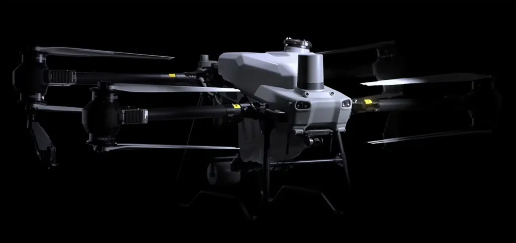
One of our flagship offerings is drone spraying, where we use advanced agricultural drones (like the DJI Agras T50) to apply crop treatments with extraordinary precision. Unlike traditional methods (such as tractor-mounted sprayers or crop-dusting airplanes), drones can target specific areas of a field and distribute fertilizers or pesticides evenly without human error or terrain limitations. Precision application means the right amount of chemical is delivered exactly where it’s needed – no more, no less. This level of accuracy is a game-changer for crop management:
Our drones fly at low altitudes following pre-programmed flight paths, ensuring consistent coverage across the entire field. Overlapping spray patterns create an even swath (the T50, for instance, can cover a swath up to ~30–36 feet wide per pass  ).
If only certain sections of a field have pest infestations or nutrient deficiencies, we can program the drone to spray only those “hot spots.” This spot-spraying approach reduces waste and prevents treating unaffected areas.
Drones spray from just a few feet above the crop canopy, which significantly reduces drift (wind blowing chemicals away) compared to spraying from tall booms or airplanes. Also, because drones are aerial, there’s no risk of trampling crops – no wheel tracks through your rows that can damage plants or compact soil.
The technology behind our drone sprayers is truly state-of-the-art. For example, the DJI Agras T50 we operate comes with a 10+ gallon tank and a dual atomizing nozzle system that can adjust droplet size on the fly  . This means we can optimize spray droplets for better leaf coverage or drift control as needed. The drone’s onboard radar and sensors help it maintain a consistent height above the crops (even if the terrain varies), resulting in uniform application. With a spraying rate that can reach up to 40 acres per hour or more in ideal conditions, we can treat large fields quickly and efficiently – often faster than ground crews could .
Adopting drone spraying offers several compelling benefits for corn, soybean, wheat and other crop farmers:
Because of the precision of drones, farmers often use less pesticide or fertilizer overall. Instead of blanket-spraying an entire field “just in case,” drones apply inputs exactly where needed. Studies and field trials have shown that drone technology can reduce pesticide usage by significant amounts – even up to 30% or more in certain precision agriculture case studies . Less chemical use means direct cost savings and also less environmental impact.
Drones eliminate the need to drive heavy equipment into a field. This is especially beneficial when fields are wet or muddy and a tractor would get stuck or cause ruts. For tall crops like corn, drones can spray from above after canopy closure, whereas ground sprayers might damage the crop. This also avoids issues like soil compaction and crop trampling that cost yield.
Farming is very time-sensitive. There are critical windows (for example, applying fungicide when corn is tasseling or wheat is heading) where missing the window could mean disease loss. Drones can be deployed quickly and flexibly, often faster than scheduling a plane or getting a big sprayer ready. We can respond swiftly to issues like a sudden pest outbreak, potentially saving a crop from severe damage. Additionally, our drones can even operate in low-light or night conditions if needed – since some pests are more active at night, nighttime drone spraying can target them at the optimal time.
In fields with steep slopes, terraces, or irregular shapes, traditional equipment may struggle or leave some spots untreated. Drones have no such limitations – they can easily fly over hills or hard-to-reach areas, giving complete coverage. As one expert noted, drones excel in spraying small or irregular fields and areas where ground sprayers or planes can’t easily operate .
With drone spraying, human exposure to chemicals is minimized. The operator can launch the drone from the field edge or even from a remote location, avoiding direct contact with pesticides. This reduces health risks for farm workers. In fact, safety is a major advantage – drones perform the hazardous task of chemical application while the pilot remains at a safe distance, lowering the chance of pesticide exposure or accidents with machinery.
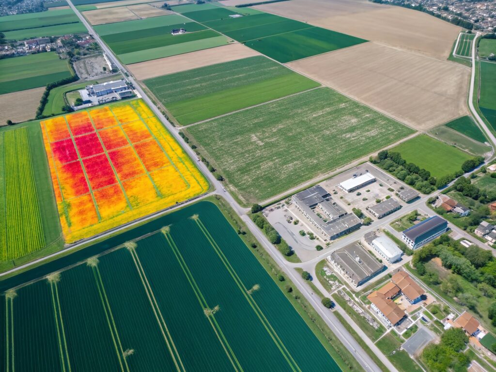
Beyond spraying, our agricultural drone services include multispectral imaging, which is like giving your crops a health scan from above. We use drones equipped with special cameras that capture light beyond what the human eye can see – including infrared bands that are very telling of plant health. By flying these sensors over a field, we generate detailed maps such as NDVI (Normalized Difference Vegetation Index) which highlight how plants are performing. Healthy vegetation reflects light differently than stressed vegetation, so these maps can reveal stress from drought, nutrient deficiencies, pest damage, or disease before it’s visible to the naked eye.
For farmers unfamiliar with drone imaging, the concept is similar to getting an early warning system for your crops:
Multispectral drone images might show, for example, a patch of soybeans that isn’t as photosynthetically active (appearing as a yellow-red spot on an NDVI map) which could indicate a pest outbreak or nutrient lack. Catching this early allows for targeted intervention (perhaps sending the drone to spray that specific patch) before the issue spreads .
We provide farmers with easy-to-understand maps and reports. For instance, our crop health report for a cornfield might highlight zones of low vigor which correlate with perhaps waterlogged soil. Knowing this, a farmer can decide to improve drainage or adjust irrigation. In wheat fields, imaging can help estimate biomass and even yield potential, aiding in harvest planning.
These drone-derived insights enable precision agriculture techniques like variable rate application. Instead of applying a flat rate of fertilizer across an entire field, a farmer could use our data to apply more in high-need areas and less in others, optimizing input use. This boosts efficiency and can improve yields by ensuring each part of the field gets exactly what it needs.
We can fly multiple times through the season – e.g., early season stand count, mid-season health check, pre-harvest condition – giving a complete picture of crop development. This timeline of data helps track the effectiveness of interventions (did that fungicide application help? Are the recovery areas improving?) and supports year-to-year learning.
© 2012–2025, aerial field services. All rights reserved.