
In today’s fast-paced project environments, accurate maps and surveys are indispensable. Aerial Field Services provides Drone Mapping & Surveying Services that deliver high-resolution maps, 3D models, and survey data faster and often more cost-effectively than traditional methods. We support a variety of applications – from construction site mapping and monitoring, to gas pad and pipeline route surveys, to agricultural land planning. Using advanced drones such as the DJI Mavic series, Matrice series, and even our Agras T50 (equipped with mapping sensors), we capture aerial data with precision and turn it into actionable insights like orthomosaic maps, topographic surveys, and volume measurements. Below, we explain the benefits of drone mapping for different sectors and how our technology (the DJI Agras T50, DJI Mavic 4, and Matrice models) contributes to high-quality surveying results.
Traditional land surveying and mapping often require significant time, manpower, and sometimes risky fieldwork. By contrast, drones can survey large areas in a fraction of the time. Studies have shown that capturing survey data with a drone is up to 5 times faster than ground-based methods and can be **60–80% more cost-effective】 . Drones flying over a site can accomplish in minutes what might take a ground crew days or weeks of labor with tapes, GPS rovers, or total stations . This speed does not sacrifice accuracy – with proper control points and high-quality sensors, aerial mapping can achieve centimeter-level accuracy, suitable for many engineering and planning purposes.
Key advantages of our drone mapping services include:
We can map hundreds of acres per day if needed. For example, mapping a 100-acre construction site with a drone might take only an hour or two of flight, whereas a field survey crew might require multiple days. Faster data means faster decision-making for your project.
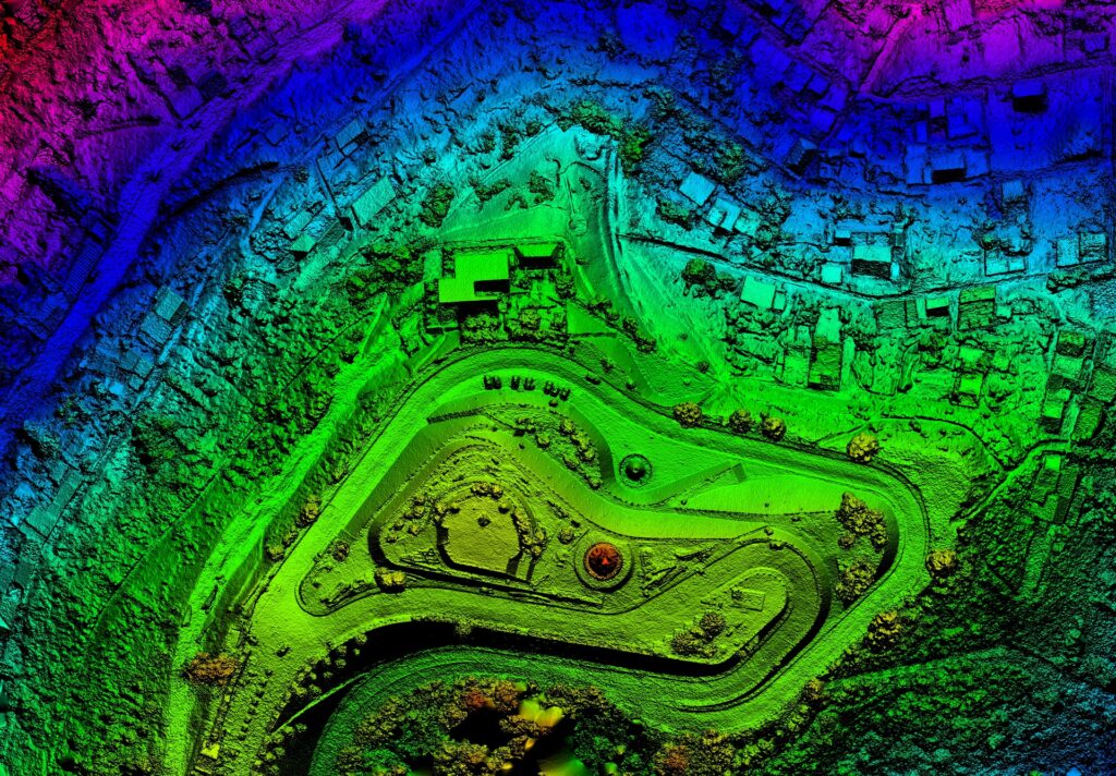
Our drones capture imagery at resolutions of 2-3 cm per pixel or better. This level of detail means you can see individual features (like manholes, fence lines, crop rows) clearly in the orthomosaic. We also generate detailed Digital Elevation Models (DEMs) and point clouds from the imagery using photogrammetry. These outputs let you examine the site in 3D, measure elevations, and extract contours.
Drones excel at surveying areas that are dangerous or difficult for humans to access. Steep stockpiles, busy road corridors, marshy ground – a drone flies over these with ease. For pipeline and gas pad development in rough terrain, our drone can safely capture all necessary topographic data without putting personnel at risk climbing hills or walking near heavy machinery.
Because drone surveys are efficient, it’s feasible to map a site repeatedly (weekly, even daily if needed). This is a boon for construction progress tracking or monitoring environmental changes. Regular drone maps create a timeline of changes – you can overlay maps from different dates to see what’s been built, excavated, or changed . This helps catch deviations from plans early, avoiding costly rework .
Less field time and automation in data capture translate to lower costs. There’s also reduced need for extensive traffic control or work stoppages on active sites; a drone mapping a construction site can often fly without interrupting ground work, whereas a traditional survey might require sections of the site to be clear. Some estimates show drone surveying can save up to 80% of the cost compared to traditional methods for large areas  .
No one has to physically traverse potentially hazardous areas (highways, mines, unstable ground). Our pilots can launch the drone from a safe location and gather all needed data remotely. This greatly enhances safety by keeping surveyors out of harm’s way  .
In construction, drone mapping has become a game-changer for site planning and monitoring. We serve construction projects by providing up-to-date aerial maps and 3D models that help engineers, project managers, and stakeholders stay informed. Here’s how our services benefit construction and development projects:
Before construction begins, our drones can perform site survey flights to capture existing conditions. From this, we produce orthomosaic maps and digital terrain models that architects and engineers use for design. It’s an efficient way to get a complete view of the site’s topography and features. For example, we can deliver a contour map showing elevation changes, which is critical for design work like drainage planning or determining cut-and-fill volumes for earthmoving.
Once construction is underway, regular drone flyovers create a visual diary of progress. Project managers can see exactly where work has been completed versus what’s pending. Using specialized software, we can even align these drone maps with project CAD drawings or BIM models to compare “as-built vs as-designed” . This helps in identifying any deviations or issues early . Instead of waiting for a problem to show up weeks later, managers can spot it in the drone imagery and take corrective action.
Need to know how much material is in that stockpile or how much dirt has been excavated? Drone surveys are excellent for volume calculations. By generating a 3D model of a pile or pit, we can calculate volumes with high accuracy – often within a few percentage points of traditional surveys. This is incredibly useful for tracking earthwork, managing inventory of aggregates, or verifying contractor work (for instance, checking that the amount of soil removed matches the plan). According to industry use cases, using drone photogrammetry for volume measurements is not only accurate but far safer and quicker than having someone climb on a pile with GPS equipment  .
High-quality aerial maps are also a great communication tool. They provide a single, easily understandable view of the whole site that can be shared with clients, regulators, or team members. When everyone can see the project from above, discussions and decisions tend to be clearer. We can annotate maps to highlight areas of interest, and produce outputs for reports or presentations that keep everyone in the loop.
At the end of a project, an aerial survey can serve as an as-built record. It documents where everything was ultimately placed. This is valuable for future facility management or if legal questions ever arise about the project’s execution. The orthomosaic serves as a timestamped snapshot of the final state of the site.
Our drones used for construction mapping typically include the DJI Mavic series (like the Mavic 3 Enterprise and upcoming Mavic 4) which are small but powerful mapping drones, and the DJI Matrice 300 RTK for larger sites or when using specialized sensors. The Mavic series offers a 20MP camera with a mechanical shutter (to eliminate motion blur during mapping) and can use an RTK module for survey-grade accuracy, ensuring our maps align with known coordinates precisely  . The Matrice, on the other hand, can carry heavier cameras or even LiDAR sensors if needed and boasts longer flight times (up to ~55 minutes ), which is great for very large sites.
© 2012–2025, aerial field services. All rights reserved.